Slacks Creek Recovery

Stretching 14 kilometres, Slacks Creek flows through the heart of our city and is a significant tributary of the Logan River. It links some of Logan’s busiest suburbs. You see it when you visit IKEA, drive over Compton Road or walk through Meakin Park.

The creek, which gave its name to one of Logan’s oldest settled suburbs, was named after the Slack family who grazed cattle in the district from about 1845. Before European settlement, the creek was known as Mungaree, meaning ‘place of fishes’, in the local Aboriginal language.

Revitalisaton works

The project work is delivered at many sites along the whole creek, with the aim at each site to:

  • restore the health of Slacks Creek
  • increase habitat for wildlife
  • improve habitat quality
  • reconnect areas of riparian vegetation
  • reconnect the local community to the creek by activating the adjacent parkland.

The works aim to improve water quality, bank stability and pollutant mitigation while increasing the knowledge and engagement of the community to better conserve, manage and protect natural resources.

Community activation

Since the launch of the Slacks Creek Recovery Plan in 2013, we have been revitalising the catchment through community led initiatives, recreational activities and public artwork activations. Over 2,000 community members have volunteered across 15 events. These have included:

  • Community walks
  • Fauna spotting activities
  • Citizen science water monitoring 
  • Tree planting
  • Clean Up Australia Day events  
  • Student-led creek planning session at Mabel Park State High School. 

To learn more, watch our 'The Human Side of Tree Planting' video and discover the connection between the plants and people of Slacks Creek.

Since 2013, public artworks have been installed in the Slacks Creek corridor public spaces. This started with a temporary installation titled “Slacks Creek Tyre Swan”. Old tyres recovered from the creek were turned into painted tyre swans.

Parkland activations have continued with the establishment of the award-winning “Slacks Track” signage and public art trail. The public art trail starts at Compton Road, with the now iconic origami cranes statues, and continuing at key park nodes through to Meakin Park. The trail includes:

  • vibrant yellow picnic shelters
  • shaded reclining sun-loungers 
  • origami boats, which are visible when crossing Slacks Creek at Paradise Road. 

Riparian rehabilitation

Riparian corridors are the land immediately alongside waterways. These corridors have had rehabilitation works completed in selected areas. 90,000 native species have been planted and weeds have been removed along 2.5 kilometres of the main Slacks Creek corridor and across another 22 hectares throughout the catchment.

Rehabilitation recreates healthy riparian corridor functions like:

  • natural habitat
  • bank stability
  • filtration of water entering the creek
  • shading
  • flood mitigation 
  • improved aesthetics.

Regular litter clean-ups have led to 15 tonnes of waste being removed from the creek. This contributed to riparian rehabilitation by improving waterway health and visual amenity. 

22,000 native plants, including 235 threatened species, have also been planted at the Griffith University arboretum. We have successfully applied for State and Federal grants to deliver parts of this project work. 

Constructed wetlands

Stormwater disconnection projects have treated approximately 30 hectares of urban runoff before it enters the creek.

Delivery of the Arlington Park Drain Naturalisation Project in 2014 was designed to :

  • enhance waterway health
  • increase in-stream habitat, and
  • improve park amenity.

The Shailer Pioneer Park wetland was funded by Logan City Council and the federal government. This constructed wetland uses the same water treatment processes that occur in a natural wetland to treat stormwater runoff and improve water quality. The design of the wetland enhances recreational amenity with the inclusion of:

  • boardwalks
  • bridges
  • viewing decks, and
  • interpretive signage.

Surveys have found that at least 5 species of native frogs are now making the wetland their home, including the threatened tusked frog and the great barred frog!

Corridor connections

Connected waterways are essential for many aquatic species, including fish. Fish move up and downstream, as well as into and out of connected wetlands and floodplains. There are many reasons they undertake these movements, including:

  • to complete all stages of their lifecycle. For example, many of our native fish migrate from the upstream freshwaters to the estuary to spawn
  • for feeding and dispersal.

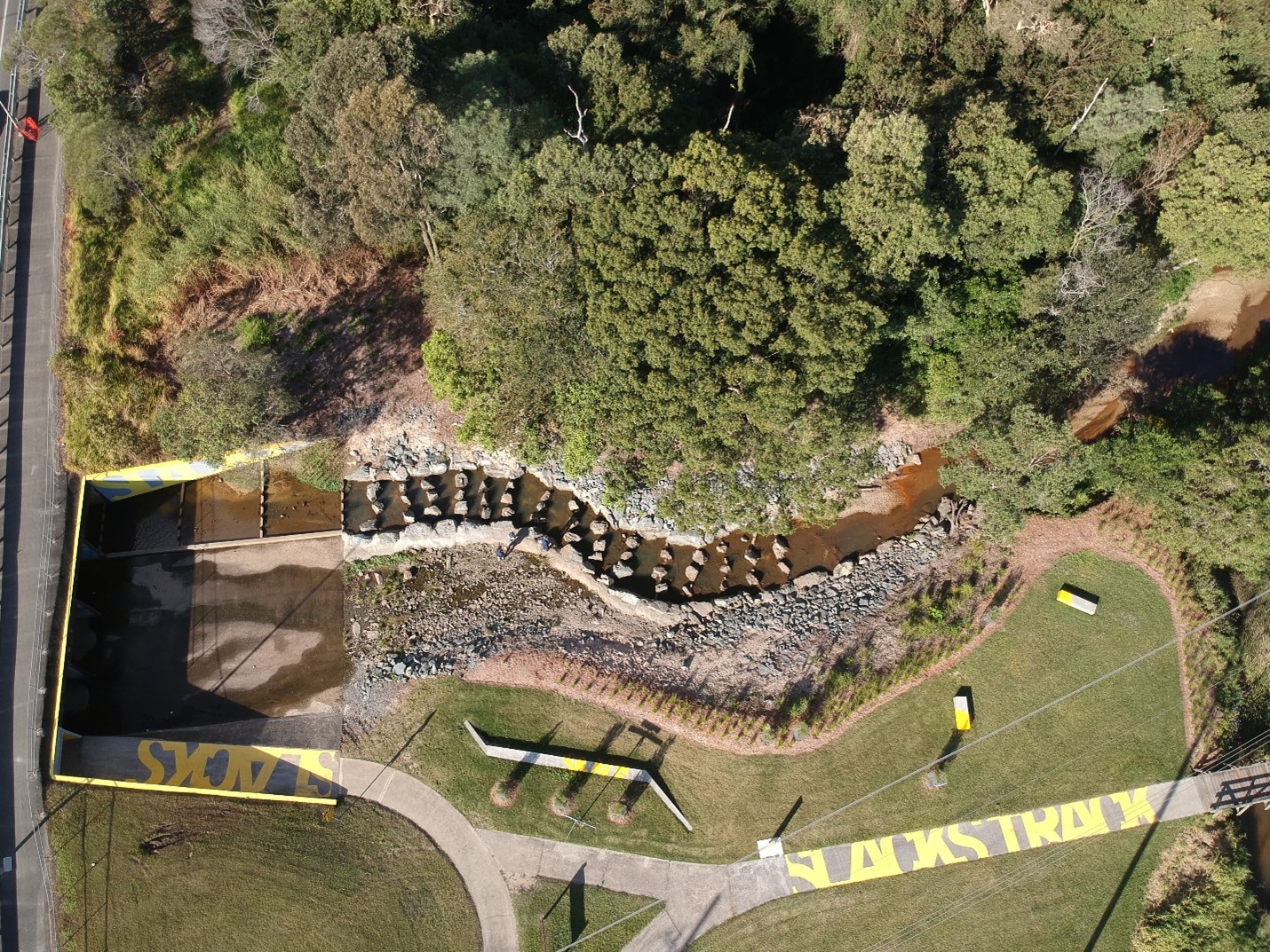
Waterway infrastructure, like dams and weirs, can sometimes act as a barrier to fish movement. In 2017, a Council and Federal Government funded project saw the Paradise Road fishway constructed.

The fishway uses corridors placed under Paradise Road for fish to move up or down stream. This project has improved connectivity and is building a more sustainable and healthy native fish population in the creek.

Monitoring has shown an increase in native fish found upstream of the Paradise Road culvert.

Drone photo of Paradise Road fishway construction along Slacks Creek