Bahrs Scrub Local Development Area Plan
The Bahrs Scrub Local Development Area Plan was released for community consultation in 2012 and endorsed on 4 December 2012 for the purpose of informing the Logan Planning Scheme, within Part 3, Strategic Framework. The plan guides development for the Bahrs Scrub area in a way that manages housing for around 10,000 people, retail, commercial and community centres, public transport and the environment. The project documentation should be considered during the development assessment process in areas designated as ‘emerging communities’.
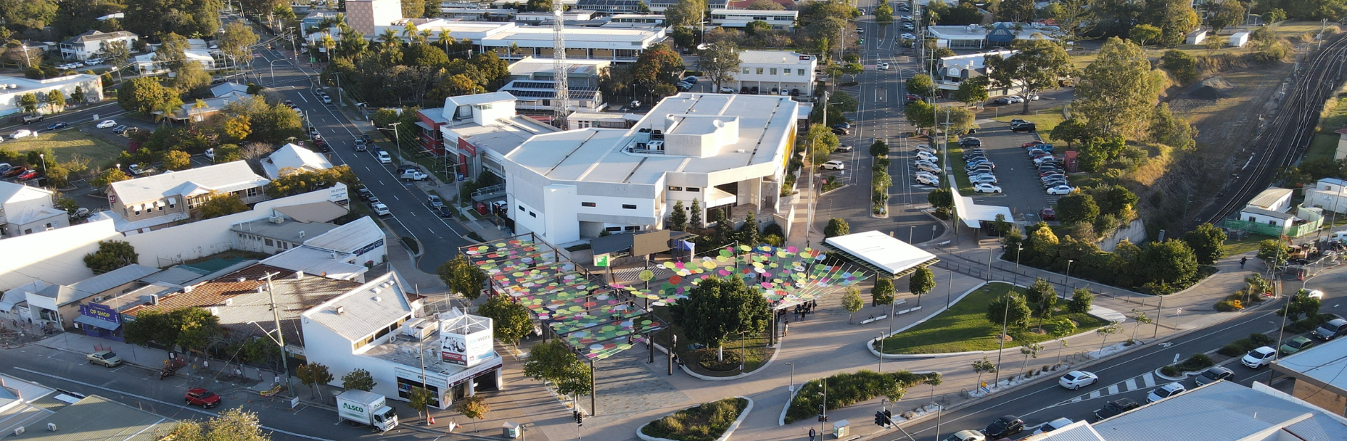
Beenleigh Town Square
The Beenleigh Town Square was a catalyst project identified in the Beenleigh Town Centre Master Plan. The space officially opened on 6 November 2015. Beenleigh Town Square can host a variety of events including:
- markets
- local festivals
- concerts.
For more information and booking details, please see Beenleigh Town Square.
Beenleigh Implementation Plan
The Beenleigh Implementation Plan(PDF, 13MB) identifies and prioritises a number of place-based actions that contributes to delivering the vision for Beenleigh. Following the Beenleigh Summit several key initiatives and actions were endorsed by Council which informed the Beenleigh Implementation Plan (2019). The Implementation Plan has been updated to reflect projects delivered since 2019 and updates to the place-based actions for the next five-year period (2023 to 2028).
Completed projects
Big LED screen in the Beenleigh Town Square
We completed the installation of a 4 metre x 3 metre LED screen above the stage in the Town Square in November 2019. The interactive screen is regularly used for movie nights and community events.
Beenleigh Town Square Shade Solution
We have installed a unique shade canopy designed by local artists to provide more shade, colour and feature lighting. The Beenleigh Town Square Shade Solution was a joint initiative of Logan City Council and the Queensland Government. It also received an Australian Urban Design Commendation Award in 2022.
Beenleigh Town Square Activation Programme
This is an ongoing free community events programme run by a dedicated place activation officer. It includes the hosting of monthly movie nights and night markets. The programme also supports community led events such as the Wardrobe Rummage and the Beenleigh Cane Festival Parade.
Free Wi-Fi in the Town Sqaure
Installation and commissioning of free Wi-Fi in the Beenleigh Town Square completed in 2019. The free Wi-Fi has improved visitation and duration of stay in the town square. In addition to the LED outdoor screen facilitates, this has improved visitor experience and the delivery of events and activities.
Beenleigh Streetscape Masterplan
The Beenleigh Streetscape Masterplan respects and builds upon the unique historical strip retail character of the centre. It aims to create a safe and enjoyable place for visitors and locals. It focusses on three core outcomes:
- restore
- reconnect
- reinvigorate.
These three core outcomes will help improve amenity, economic vitality and social cohesion to the town centre over time.
Beenleigh Streetscape Upgrades
We have enhanced key streets and laneways in the town centre to improve public safety and access by:
- wider footpaths
- improved signage
- more pedestrian crossings.
New seating and feature lighting has led to increased pedestrian activity both during the day and at night. This will support local businesses with more passing trade.
The Beenleigh Streetscape Upgrades were a joint initiative of Logan City Council and the Queensland Government. It also received an Australian Urban Design Commendation Award in 2022.
Smart Parking
Council installed parking sensors that give user-friendly real-time parking information. Motorists can locate vacant car spaces by using the parkspot app on their smart phones. The sensors give detailed data on parking occupancy and duration. This data will help guide future parking provision in the Town Centre.
Wayfinding and Signage
Council installed new signage to assist people to find their way around Beenleigh. The unique signage design includes a universally recognizable pictogram design for easy recognition by all community members. A unique signage suite has been designed and includes: directional finger signs, pedestrian information maps and digital parking signs which will be progressively installed across the town centre.
Beenleigh Centre Advisory Group
The Beenleigh Centre Advisory Group (BCAG) represented local residents, businesses, property owners, retailers and other stakeholders. Between December 2018 and November 2020 BCAG provided input and guidance to Council on the detailed design and delivery of the Beenleigh Implementation Fund Projects.
Beenleigh Summit
For more information and outcomes from the Beenleigh Summit, please see the Beenleigh Summit information (PDF 3.9 KB).
Invest in Beenleigh
Beenleigh's proximity to the Gold Coast and Brisbane, combined with its affordable land prices and educated workforce, makes it an attractive location for investors, developers and business entrepreneurs. The top five economic sectors, which contribute to 56% of employment in Beenleigh, are:
- retail
- health care and social assistance
- public administration and safety
- manufacturing
- accommodation and food services.
Key organisations involved in Beenleigh's renewal and investment program are the Logan Office of Economic Develpment and the Beenleigh Yatala Chamber of Commerce.
Jimboomba Implementation Plan
The Jimboomba Implementation Plan(PDF, 5MB) identifies and prioritises a number of place-based actions that contributes to delivering the vision for Jimboomba. Following the Jimboomba Summit several key initiatives and actions were endorsed by Council which informed the Jimboomba Implementation Plan (2019). The Implementation Plan has been updated to reflect projects delivered since 2019 and updates to the place-based actions for the next five-year period (2023 to 2028).
Projects underway
Cucack Lane Streetscape Enhancement Project
The project is for the design and construction of the street scape enhancement within Jimboomba. This includes development of a streetscape master plan for key streets in Jimboomba, providing more shade including trees and more places to sit and relax including informal spaces/parklets, street furniture, public art and on-street dining opportunities.
Streets to be included in this master plan include Cusack Lane, Johanna Street, Honora Street and Mt Lindesay Highway, with the main focus on the Cusack Lane/Brisbane Street entry. The project started planning and design and is expected to be completed in 2023/2024.
Find out more about the project.
Jimboomba Town Centre Working Group
The Jimboomba Town Centre Working Group represents local residents, businesses, property owners, retailers and other stakeholders. The group started in November 2020 and meets every two months. The group gives input and guidance to Council on the detailed design and delivery of the Jimboomba Implementation Fund Projects.
Projects completed
Safe crossing trial
The Jimboomba Summit identified a new pedestrian connection across Mount Lindesay Highway as a key priority for the local community. Another priority was to revitalise the unused railway corridor.
The safe crossing trial will create a temporary structure under the Mount Lindesay Highway that will connect the eastern side of Jimboomba with the Jimboomba town centre. Public lighting and CCTV was provided for community safety.
The pathway will provide a safe pedestrian crossing until the Department of Transport and Main Road’s upgrade of the Mount Lindesay Highway.
The project started in January 2021 and concluded in March 2022 when the Department of Transport and Main Roads completed a more permanent pathway under the Mount Lindesay Highway.
Jimboomba Summit (March 2019)
The Jimboomba Summit was held on 21 March 2019. The Summit was held to ask for feedback from the community to guide future initiatives and activities in Jimboomba. Outcomes of the summit will guide our work and the work of other stakeholders.
For more information and outcomes of the event, please download the Jimboomba Summit (PDF 185 KB) information.
Jimboomba Local Plan (April 2010)
The Jimboomba Local Plan has been completed (endorsed on 22 April 2010) and has been incorporated into the Logan Planning Scheme (refer to the Jimboomba Local Plan in Part 7), which now guides decision making in this area.
Jimboomba Place Activation and Events Strategy
Logan City Council was successful in securing a $100,000 funding grant under the Federal Building Better Regionals Community Investments Stream Round 4, with the aim to deliver the Jimboomba Place Activation and Events Strategy(PDF, 6MB) over a five-year period.
The strategy will be central to solidifying Council’s commitment to tourism, growth and delivering further vibrancy and activity to Jimboomba. On Saturday 17th September 2022 in partnership with BBQ Beer and Roadshow, Council hosted the first FLAME BBQ Street Festival on Cusack Lane and Brisbane Street in Jimboomba.

Logan Central Implementation Plan
The Logan Central Implementation Plan(PDF, 17MB) identifies and prioritises a number of place-based actions that contributes to delivering the vision for Logan Central. Following the Logan Central Summit several key initiatives and actions were endorsed by Council which informed the Logan Central Implementation Plan (2019). The Implementation Plan has been updated to reflect projects delivered since 2019 and updates to the place-based actions for the next five-year period (2023 to 2028).
Croydon Road Streetscape Upgrade Works (2024)
Croydon Road was identified as a catalytic project in the Croydon Road Precinct Streetscape Master Plan.
This work builds on the master plan guidelines to improve public space amenity and activation of the Croydon Road Precinct. The project will improve the section of Croydon Road between Station Road and Blackwood Road. It also includes a new toilet block on the corner of Blackwood and Croydon Roads.
The streetscape upgrade is jointly funded by Council and the Queensland Government.
Detailed design is complete for the Croydon Road shared zone.
Construction will start in January 2024 and is expected to finish in September 2024.
For more details and to stay up to date on the project visit Croydon Road Streetscape Upgrade.
Croydon Road Place Activations
We hosted a series of activations and events to involve the local community in the design of the street improvements.
- Colours on Croydon (February 2023) – a two-day activation to test the shared zone concept with art activities.
- Tastes of Croydon (March 2023) – a mini street festival to test activating public space with creative lighting, local food, and community performances.
Croydon Road Streetscape Master Plan (May 2022)
The Croydon Road Precinct Master Plan and Streetscape Guidelines incorporate the existing standards from the Planning Scheme Policy 5 and the Logan City Landscape Development Manual. This document looks to create further defined guidelines in the locally significant area of Croydon Road.
The master plan aims to provide a coordinated approach to the design and implementation of streetscape works in the Logan Central area. They inform the selection of hardscape and softscape elements to be used in urban centres across a range of scenarios and identify key design opportunities for the area.
The master plan also provides a framework for the development industry, planning and design professionals, Council officers and the Logan community to ensure that the street landscape delivers high quality urban outcomes for the area.
For more information, download The Croydon Road Precinct Master Plan and Streetscape Guidelines (PDF 87.6 MB)
Logan Gardens Shared Parkway Project - Civic and Community Precinct (Construction underway Oct 2023)
The Logan Gardens Shared Parkway Project is a priority capital works project identified from the Logan Central Civic and Community Precinct Plan.
The shared Parkway is a shared zone that will provide improved pedestrian and cycle access through Logan Gardens. It will unlock the full recreational potential of this valuable park. The shared Parkway is designed to prioritise pedestrian, cycle and scooter users. Vehicles will be permitted via controlled access to the shared Parkway at a slow speed (10km/h) during daylight hours. This will provide more parking options and improved access for visitors to enjoy the gardens. Lighting and CCTV will improve safety with increased visitation to the area.
The project is jointly funded by the State Government and Council. Council will use funds from the Logan Central Implementation Fund.
The project is currently in the construction phase.
The community was invited to provide feedback on the concept design and submit other ideas for the Logan Gardens between November 2022 and January 2023.
For more information see the project page.
Civic and Community Precinct Plan (June 2021)
The purpose of the Logan Central Civic and Community Precinct Plan, endorsed June 2020, is to provide an integrated long-term vision for the precinct. The plan supports the development of a safe and healthy community along with the city’s sustainability strategy. It will contribute to the development of a strong local economy through investment attraction over the next 10 to 30 years.
The Logan Central Civic and Community Precinct Plan provides an integrated framework to reposition the precinct within Logan and South-East Queensland.
The precinct plan is designed to achieve maximum economic, lifestyle and sustainability benefits for the community by providing clear development recommendations for this pivotal city land parcel.
The plan identifies practical strategies that will uplift the wellbeing of the urban setting and increase the sites visitor and resident populations by embracing and growing Logan’s most valuable and undervalued assets, its people, their energy, and diversity of culture.
The Precinct Plan reconnects parts of the precinct through the insertion of a street network that unlocks full use of the whole precinct. The plan centres the precinct energy to the centre through:
- ideas of activation
- blending higher density residential uses into the local neighbourhood
- provides a greater choice for access and mobility
- challenges the trend of traffic-dominated streets, reshaping them for the enjoyment of the community
- envisioning a greener, cooler, better connected public experience.
In repositioning the precinct, we can create a place where the city’s diverse and vibrant community come together to learn, do business, celebrate and socialise. Bringing people together will:
- improve strategic and social interaction
- drive increased residential, civic, allied health, recreational and commercial site populations
- uplift economic performance
- provide precinct wide safe and equitable accessibility.
The Civic and Community Precinct Plan received 2021 AILA National Landscape Architecture Award for Urban Design.
For more information, see The Civic and Community Precinct Plan.
Logan Central Implementation Plan (February 2019)
The Logan Central Implementation Plan (PDF 5.86 MB) was approved on 26 February 2019 to guide the planning and delivery of priority projects and programs in Logan Central.
The plan builds on the overall aims of the Logan Central Master Plan and includes the outcomes of the Logan Central Summit.
Logan Central Summit (May 2018)
The Logan Central Summit was held on 11 May 2018.
It focused on ways that government, industry, business owners, landowners and the community can collaborate to harness strengths and capitalise on opportunities to develop Logan Central as the civic and cultural heart of the city.
For more information and outcomes of the event, please download Logan Central Summit (PDF 3.5 KB) information.
Logan Central Master Plan (November 2014)
The Logan Central Master Plan (PDF 6322 KB) provides the strategic vision to guide development in Logan Central and realise its potential as the cultural and civic heart of Logan City (as identified in the South East Queensland Regional Plan 2009–2031).
Council endorsed the Logan Central Master Plan on 18 November 2014. It informed the development of the Logan Central Local Plan, was incorporated into the Logan Planning Scheme (refer to Logan Central Local Plan in Part 7), and now guides decision making in this area.
Logan Central Affordable House Project (June 2013)
Logan City Council, the Australian Government and Horizon Housing formed a partnership to deliver an affordable housing demonstration project (PDF 2571 KB). Tallowwood on North is an innovative residential development that showcases high-quality urban design and a range of affordable housing options. Completed in June 2013 with funding from the Australian Government's Liveable Cities Program.
Loganholme Neighbourhood Plan (May 2013)
The Loganholme Neighbourhood Plan (PDF 10.66 MB) guides development in Loganholme over the next 20 years. It has been completed and is provided as background/reference material only – it should not be relied upon as part of the development assessment process.
The Loganholme Neighbourhood Plan was incorporated into the Logan Planning Scheme (refer to Loganholme Local Plan in Part 7), which now guides decision making in this area.
Loganlea Neighbourhood Plan
The Loganlea Neighbourhood Plan provides a vision for accommodating growth in Loganlea in line with the Queensland Government’s South East Queensland Regional Plan 2009-2031. It has been completed and has been incorporated into the Logan Planning Scheme (refer to the Loganlea Local Plan in Part 7), which now guides decision making in this area.
Logan Reserve Plan
The Logan Reserve Plan (PDF 3.42 MB) has been completed and is provided as background/reference material only – it should not be relied upon as part of the development assessment process.
The Logan Reserve Plan was incorporated into the Logan Planning Scheme (refer to the Logan Reserve Land Use Area figure in Part 3 Strategic Framework), which now guides decision making in this area.

Logan Village Implementation Plan
The Logan Village Implementation Plan(PDF, 12MB) identifies and prioritises a number of place-based actions that contributes to delivering the vision for Logan Village. Following the Logan Village Forum several key initiatives and actions were endorsed by Council which informed the Logan Village Implementation Plan. The Implementation Plan has been updated to reflect projects delivered since 2018 and updates to the place-based actions for the next five-year period (2023 to 2028).
Projects in Progress
Logan Village Green Stages 2b and 3
The next phase of Logan Village Green upgrades will start in May 2024. The project includes:
- adding new green space between the RSL Cenotaph and community centre, replacing the existing carpark. This provides more space for community recreation and memorial related events
- the heritage courtyard will be upgraded with seating, shelter, trees and landscaping to create a gathering area
- these works also include resolving drainage issues improving the safety and functionality of the space.
The expected completion date is July 2024.
Both stages of work are consistent with the Logan Village Green Masterplan.
Logan Village Riverfront Precinct Plan
The Logan Village Riverfront Precinct Plan(PDF, 9MB) creates a framework to plan, design and deliver already identified priority actions (from the Logan Village Forum, the Logan Village Implementation Plan and the Logan River Vision) in a complementary manner that builds upon the momentum of place-based actions in the Logan Village Green and its surrounds. The Precinct Plan provides an opportunity to realise ‘A shared community place where people can exercise, relax and embrace the natural and heritage significance of the Logan River’ (Logan Village Riverfront Precinct Plan: Vision Statement). Delivering public access to the Logan River will re-establish a significant heritage connection and create a unique regional scale attraction that will draw people into the area and generate economic opportunities for the wider community. The Precinct Plan was endorsed by Council in November 2023.
Completed projects
Upgrade to Logan Village Green
To enhance what is the focal point of the Logan Village community, the Logan Village Green was redeveloped in 2022 to improve:
- drainage conditions
- landscaping
- lighting, and
- signage.
This project includes:
- a new tree lined circular path that frames a central events space
- new park furniture
- a new half-court basketball court
- parking, and
- lighting.
The $1.2 million project is a joint initiative of Council and the Federal Government under the Local Roads and Community Infrastructure Program.
Relocate the Skate Park
The old skate park was demolished and replaced with a purpose-built park in the southwest corner of the Village Green. The new skate park provides a high-quality experience for the riders of all ages and abilities. The new skate park also includes lights to ensure the use of this prized asset is maximised, promoting an extended activity profile in the Village Green.
The new skate park was officially opened in November 2022 with guest attendee gold medallist Logan Martin.
Logan Village Place to Play
The new Logan Village Adventure Playground, located on the village green, was officially opened in May of 2021. This landmark project delivers on a community priority as identified in the Implementation Plan.
A community inspired design process was key to the project delivery. The new playground includes a distinctive bird's nest lookout, slides, trampolines, a flying fox, totem poles with ropes and a dry creek bed flanked by timber steppers and balance beams.
The $1.6 million project was jointly funded by Council and the Federal Government under the Building Better Regions Fund Round 3. The highly collaborative project was awarded both the Stakeholder Engagement Award and the overall project winner by the Planning Institute of Australia (PIA) QLD 2021.
Logan Village Green Master Plan
A key outcome from the Logan Village Forum was the development of a precinct master plan for the Village Green precinct, working with affected landowners, user groups, community groups and local businesses. The Logan Village Green Master Plan (PDF 10 MB) provides the framework to facilitate the upgrading, improved embellishment and/or expansions of the Village Green. The Logan Village Green Master Plan was endorsed by Council in 2020.
Logan Village to Yarrabilba Rail Trail
The Logan Village to Yarrabilba Rail Trail was officially opened in December 2021. The 3.5 km rail trail re uses the old Bethania to Beaudesert rail corridor and creates an active link between Logan Village and Yarrabilba. The 2.5m wide asphalt pathway extends through native bushland and is designed for walking, jogging, hiking and cycling.
The rail trail features a watercourse crossing, flood mitigation, access-controlled bollards and custom design signage. The entry signs include repurposed ironwork from the old bandstand on the Village Green.
The $2.6 million project is a joint initiative of Council and the State Government who contributed $2 million under the Unite and Recover grant funding program.
My Home and the River Link
The Logan Village River Link was opened in August of 2021. The link provides a direct connection between the residential areas south of Anzac Avenue to the Logan Village Green. The 2.5 metre wide path, bridge and underpass are improved by unique views of the river and its surrounds. The project includes new safety cameras, lighting and a viewing platform that overlooks the river.
The $1.2 million project was funded through the Logan Village Implementation Fund to improve connectivity, to improve engagement with the Logan River and promote active forms of transport.
Logan Village Events Strategy
The Logan Village Events Strategy provides a framework for planning and delivering events in Logan Village. The strategy was informed by community consultation including an ideation workshop in December of 2020.
The Logan Village Event Prospectus is the key product of this project delivered in August 2021. The prospectus sets out a series of opportunities for local businesses and organisations to partner with Council to develop their own unique event. The project was delivered with a 50% funding grant under the Building Better Regions Fund Round 3.
Free Wi-Fi to the Logan Village Green
Free wi-fi to the Logan Village Green was installed in July 2019 to assist in building community activities and supporting proposed events.
Logan Village Advisory Group (December 2018)
The Logan Village Advisory Group (LVAG) represented local residents, businesses, property owners, retailers and other key stakeholders. Between December 2018 and November 2020 the LVAG gave input and guidance to Council on the design and delivery of Logan Village Implementation Fund Projects.
Logan Village Forum (March 2018)
The Logan Village Forum, held on 7 March 2018, brought together the community, government, industry, business owners and property owners to talk about the economic and community potential for Logan Village. For more information and outcomes of the event, please download the Logan Village Forum information (PDF 583 KB).
Logan Village Local Plan (March 2010)
The Logan Village Local Plan guides development in the area over the next 20 years to cater for the needs of its existing and future residents. The plan was endorsed on 30 March 2010 and has been incorporated into the Logan Planning Scheme (refer to the Logan Village Local Plan in Part 7), which now guides decision making in this area.
Loganlea Road Healthy Street Project (December 2021)

Meadowbrook Implementation Plan
The Meadowbrook Implementation Plan(PDF, 26MB) identifies and prioritises a number of place-based actions that contributes to delivering the vision for Meadowbrook. Following the Meadowbrook Summit several key initiatives and actions were endorsed by Council which informed the Meadowbrook Implementation Plan (2019). The Implementation Plan has been updated to reflect projects delivered since 2019 and updates to the place-based actions for the next five-year period (2023 to 2028).
After the Meadowbrook Summit in 2018, we started the design of the Loganlea Road Healthy Street project. The goal of the project was to reimagine and rebuild Loganlea Road into a Healthy Street. The project opened in December 2021.
The project has delivered:
- A new signalised pedestrian crossing on Loganlea Road for better connectivity and safety. The crossing is located between the Logan Hospital and Meadowbrook Shopping Centre
- Provision of 1.3kms of shared paths from Loganlea rail station to the Logan Motorway
- Repairing and rebuilding the ecology of the area by planting shrubs, ex-ground bottle trees, established trees and ground covers to create shade
- Removal of 4 slip lanes and reclaiming pavement for planting and replacement of all non-DDA compliant infrastructure
- Improved accessibility for vulnerable users and those with varying levels of mobility
- 9 Logan artists created custom artwork for:
- 10 by 8-metre-high custom illuminated disc structures
- 11 shade structures
- 32 pavement stencils
- The colour palette used on street furniture, artwork and shade structures is unique to Meadowbrook and reflects the Place Branding strategy
- Installation of custom designed:
- seating
- Benches
- bike racks
- bins
- New CCTV cameras and upgraded street lighting along the entire corridor.
The final design creates a unique space through use of strategic land use planning, branding, and curation of artwork within a space.
The $5.4 million project was funded by Council and the Queensland Government.
The project received a commendation in the Movement and Place category at the 2022 Minister’s Urban Design Awards.
Stage 2
The next stage of this project involves the revitalisation of an area referred to by locals as the “Cloverleaves”, which is underutilised land which sits between Loganlea Road and the Logan Hospital Carpark.
The Loganlea Road Healthy Street Stage 2 (Cloverleaves Revitalisation – East) will involve the following:
- 1 x full sized basketball court and 1 x futsal court – both will be fully fenced with lighting and vibrant court markings
- 1 x outdoor gym with soft fall within the shaded area of the existing trees to the north
- Street furniture and shelters through the project area
- The provision of 2 x yarning circles and areas of contemplation for users of the centre
- 3 x 4.5m disc sculptures, featuring 5 pieces of art from local Logan Artists
- A healthy circuit around the cloverleaf to encourage people to walk through the area, and experience the various areas on site including the courts, recreational equipment and natural landscaping
- Significant landscaping, including ex-ground trees
- 2.5-3m wide shared paths internally and connecting externally
- Installation of 2 new security cameras
- Upgraded street lighting within the area, enhancing safety.
Construction on Stage 2 commenced in April 2023.
For all enquiries regarding this project, please contact meadowbrook@logan.qld.gov.au.
Meadowbrook Implementation Plan (February 2019)
The Meadowbrook Implementation Plan (PDF 8.54 MB), approved in February 2019, guides the planning and delivery of priority projects and programs in Meadowbrook.
Meadowbrook Summit (September 2018)
The Meadowbrook Summit, held on 20–21 September 2018, focused on ways to stimulate healthcare investment and tertiary education in the Meadowbrook area. Discussion centred on expanding Logan Hospital, supporting nearby educational institutions and developing transport infrastructure. For more information and outcomes of the event, please download the Meadowbrook Summit information.
Meadowbrook Master Plan (December 2016)
The Meadowbrook Master Plan, endorsed on 6 December 2016, describes how we propose to create a place focused on health, education and wellbeing.
The master plan is a non-statutory document that describes our vision for this area and can be used as a guideline for development assessment purposes. We intend to incorporate the Meadowbrook Master Plan into the Logan Planning Scheme in a future amendment.
Park Ridge General Planning Layout (November 2014)
The Park Ridge General Planning Layout sets out the desired land uses and road layout for the Park Ridge area.
The general planning layout was endorsed on 18 November 2014 and is now referred to in Schedule 6, Planning Scheme Policy 5 of the Logan Planning Scheme.
Planning Scheme Amendment 2009 No. 5 (Park Ridge Structure Plan)
The Park Ridge Structure Plan took effect on 11 November 2011 and was incorporated in the Logan Planning Scheme 2006.
The plan guides development in the Park Ridge area to achieve an integrated, well-planned, well-serviced urban community and employment area defined by an extensive network of parks and waterways. The plan includes the Park Ridge Dominant Land Use Plan and the Park Ridge Amendment Area Development Sequencing Plan.
The Park Ridge Structure Plan project has been completed and is referred to in the Strategic Framework (Part 3) of the Logan Planning Scheme. The project documentation should be considered during the development assessment process in areas designated as ‘emerging communities’.
Park Ridge South and Chambers Flat
The Park Ridge South and Chambers Flat Plan was developed to guide future development and primarily residential growth in the area. The plan has been completed and has been incorporated into the Logan Planning Scheme (refer to Part 7 Planning Layouts in Schedule 6, Planning Scheme Policy 5 Infrastructure), which now guides decision making in this area.
For more information, please download the Park Ridge South and Chambers Flat Documentation.
Springwood Implementation Plan
The Springwood Implementation Plan(PDF, 20MB) identifies and prioritises a number of place-based actions that contributes to delivering the vision for Springwood. Following the Springwood Summit several key initiatives and actions were endorsed by Council which informed the Springwood Implementation Plan (2019). The Implementation Plan has been updated to reflect projects delivered since 2019 and updates to the place-based actions for the next five-year period (2023 to 2028).
Springwood Implementation Plan Projects (2018 to 2023)
The Springwood Implementation Plan Fund will be used to deliver on priority projects identified from the Springwood Summit to unlock the city-making potential of the Springwood activity centre. Projects identified after the summit are included in the Springwood Implementation Plan. For more information about the plan, please download Springwood Implementation Plan (PDF 7.2 MB).
These projects will be rolled out on a medium to long term basis prioritised through future community and stakeholder engagement. The Springwood Implementation Projects include:
Place Activation Projects
The Springwood Wardrobe Rummage event was held on Saturday 18th June 2022 at Carol Park in Springwood (the Laurinda Crescent Shared Pathway). A total of 42 public and 4 community stall holders were at the event with over 500 people attending. The second-hand treasures themed market included stall holders selling clothing, accessories, bric-a-brac, books etc. There were also food & beverage stalls and live music presence in the event. Feedback from the public was very positive as it was a great success.
A second Rummage event was held at Carol Park on 27 August 2023.
Slacks Creek Green Link
The project was completed in May 2020 and now connects Compton Road with Moss Street by the creation of a new 3m wide shared pathway. The pathway will meanders through parkland with a new bridge to connect both sides of the creek and includes improved landscaping in the Slacks Creek Catchment, shade structures, bins and lighting, and integration of cycling infrastructure with open space and public art. For a copy of our factsheet, please download Slacks Creek Green Link (PDF 588 KB).
Carol Avenue to Laurinda Crescent Pathway
The project was completed in June 2020 and includes a new 3m pedestrian and cycle connection between Laurinda Crescent and Carol Avenue. It will includes park lighting, CCTV, public art, planting, street furniture, and shared off road facilities. For a copy of our factsheet, please download Carol Avenue to Laurinda Crescent Pathway (PDF 1.80 MB).
Shared Pathway between Murrajong Road and Dennis Road (School Pathway)
The project was completed in May 2020 and includes a new 3m pedestrian and cycle connection between Murrajong Road and Dennis Road. The project will includes LED lighting, CCTV, public art, landscaping, seating, fencing along the school, and a shade structure. These changes provides improved safety and walkability for local residents, students, school staff and local employees. For a copy of cour factsheet, please download Shared pathway between Murrajong Road and Dennis Road (PDF 1.33 MB).
Murrajong Road, Briggs Road, Paxton Road and Carol Avenue Streetscapes
This project, completed in May2020, delivers streetscape enhancements along Murrajong Road, Briggs Road, Paxton Road and Carol Avenue.
It will includes gardens, landscaping, pedestrian lighting, public art and street furniture with a key outcome of the project is the improved amenity and walkability of the streets and contributing towards a positive image for Springwood.
Springwood Summit (October 2016)
The Springwood Summit, held on 21 October 2016, brought together key government and industry stakeholders, as well as business owners and landowners, to unlock the economic and placemaking potential for Springwood. For more information or outcomes of the event, please download the Springwood Summit (PDF 282 KB) information.
Greater Springwood Master Plan (October 2009)
The Greater Springwood Master Plan was endorsed in October 2009 to guide the future growth of Springwood to 2031. The plan addressed the development opportunities and challenges of the area. It responded to the requirements of the South East Queensland Regional Plan 2009–2031 and community/stakeholder expectations.
The Master Plan informed the Springwood Local Plan, which was incorporated into the Logan Planning Scheme (refer to the Springwood Local Plan in Part 7), and now guides decision making in this area.
Slacks Creek Implementation Plan
The Slacks Creek Implementation Plan(PDF, 24MB) identifies and prioritises a number of place-based actions that contributes to delivering the vision for Slacks Creek. Following the Springwood Summit several key initiatives and actions were endorsed by Council which informed the Springwood Implementation Plan (2019). The Slacks Creek Implementation Plan has extracted the Slacks Creek specific actions from Springwood Implementation Plan, and has been created to reflect projects delivered since 2019 and updates to the Slacks Creek place-based actions for the next five-year period (2023 to 2028).
Slacks Creek priority projects completed
Slacks Creek Green Link – Stage 1 (Baker Street to Moss Street)
The project was completed in May 2020 and now connects Compton Road with Moss Street by the creation of a new 3m wide shared pathway. The pathway will meanders through parkland with a new bridge to connect both sides of the creek and includes improved landscaping in the Slacks Creek Catchment, shade structures, bins and lighting, and integration of cycling infrastructure with open space and public art.
3D models for the major centres at Springwood, Logan Central, Beenleigh and Meadowbrook are available for viewing on the Interactive Mapping tool in the Logan PD Hub. You can navigate to one of the centres and select the 3D tab.
The 3D models map (PDF 3.74 MB) outlines the capture areas for the 3D models and the location of each centre within Logan.